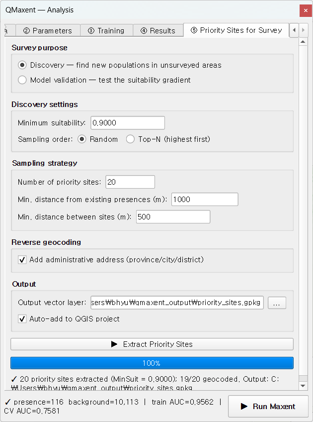
⑤ Priority Sites for Survey
The fifth tab turns a habitat-suitability raster into a field-ready list of candidate survey sites. There are two distinct purposes — discovering new populations versus validating the model — and QMaxent supports both with separate sampling strategies grounded in the survey-design literature.
Survey purpose
Pick one:
| Mode | Goal | Reference |
|---|---|---|
| Discovery | Find new populations in unsurveyed high-suitability areas | Williams et al. 2009 |
| Model validation | Test whether the suitability gradient predicts presence/absence | Rhoden, Peterman & Taylor 2017 |
The two modes ask very different questions of the same map, so they sample it differently:
- Discovery preferentially picks the highest-suitability cells far from any known occurrence — the most informative locations for finding the species where it has not been recorded yet.
- Model validation stratifies the suitability gradient and samples proportionally within strata — the design needed for an unbiased presence/absence test of the model's calibration.
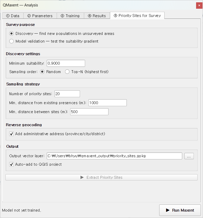
Sampling strategy
A second drop-down picks the within-mode sampling strategy:
| Strategy | What it does |
|---|---|
| Top-N (highest first) | Take the top-N cells by suitability, subject to spacing constraints |
| Threshold-stratified | Divide cells above the minimum suitability into N quantile bins and sample equally from each |
| Random above threshold | Random draw from cells above the minimum suitability |
Top-N is the right choice when you want to maximise hit-rate (the classical Discovery design of Williams et al. 2009). Threshold-stratified is what Rhoden, Peterman & Taylor 2017 recommend for model validation because it gives the test the statistical power to detect a declining presence-rate across the suitability gradient.
Spacing constraints
Two distance fields define the spatial structure of the sampled set:
- Minimum distance from existing presences — keeps candidates away from known occurrences. Set to the species' detection radius (e.g. 1 km for a calling fairy pitta, 200 m for a sessile slug). This prevents the algorithm from re-sampling territory already covered by earlier surveys.
- Minimum distance between candidates — keeps the candidate set spatially independent. A typical value is half the minimum distance from existing presences. Whittaker-style spatially balanced sampling, in the sense of Stevens & Olsen 2004, is approximated by setting this value to the median nearest-neighbour distance you want in the final set.
QMaxent enforces both constraints exactly — candidates are dropped, not moved, when a constraint is violated, so the surviving set is always within-spec.
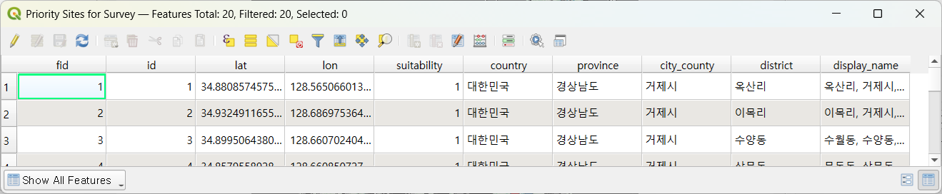
Reverse geocoding
When the Reverse-geocode addresses checkbox is on, QMaxent calls the
Nominatim API for each candidate point and adds
columns for country, province, city_county, district, and a
human-readable display_name. This makes the resulting GeoPackage
directly usable for permit applications and field-team coordination —
particularly valuable in jurisdictions where survey access requires
prior administrative notification.
The geocoder is rate-limited to one request per second to comply with Nominatim's public-server fair-use policy; for large candidate sets (>1,000 points) consider running the extractor in batches or pointing QMaxent at a self-hosted Nominatim instance via the Advanced options.
Outputs
After clicking ▶ Extract Priority Sites, two outputs are produced:
priority_sites.gpkg— a GeoPackage layer auto-loaded into QGIS and styled with red point symbols.- A
Priority sitessheet appended to the existingresults.xlsxworkbook, with the same columns as the GeoPackage attribute table.
The candidates are immediately ready for export to mobile-GIS apps such as QField, Mergin Maps, or Locus Map for offline field use.
Choosing parameter values
Some practical defaults from the literature:
- Number of candidates: 20–30 per species per season is a typical field-survey budget for a single team (Robinson et al. 2018).
- Minimum distance from existing presences: the species' typical home-range diameter is a good starting point. Too small and you re-sample known sites; too large and you push candidates into marginal habitat.
- Minimum suitability: 0.5 for a balanced search; 0.7+ for a focused high-confidence survey; lower (0.2–0.3) for negative controls in a model-validation study.
Worked applications
- The Bradypus example walks through a Discovery extraction at landscape scale.
- The Pitta nympha example shows the same workflow at municipality scale, with reverse-geocoded Korean administrative addresses ready for field permits.
Next
Move to Saving and reusing models to learn how to share the trained model with collaborators or re-project it onto a new raster stack later.